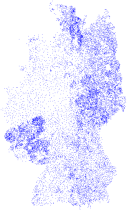
D-Sat
D-Sat was a series of CD/DVD-ROMs from the 1990s which contained aerial and satellite imagery of Germany.1 At that time, this was a milestone, since such imagery was not readily available (with web-based services appearing only a couple of years later). The data was stored in a proprietary file format and thus can only be used with the original Windows programs. Since this is not sustainable, this project seeks to reverse-engineer the file format of D-Sat 1 and develop tools to access the contained data (coordinates, images, etc.).
The first post on decoding the city database is a good starting point for further reading.
-
The CD-ROMs of D-Sat 1 have been archived by the Internet Archive. ↩
Posts
Posts with tags: cis-cod, coordinates, dsat, tiles
-
Documenting the CIS/COD image format
After having acquired an almost complete understanding of the file format of D-Sat 1, two important steps remain to make the satellite images accessible: 1) understanding how to geo-reference the tiles and 2) understanding how to process the tiles, that is, open and transform them. The second step requires an understanding of the CIS/COD raster image file format – an endeavour where we have made quite some progress during the last year. To document our findings we have set up a dedicated web page for documenting the CIS/COD image format that is online since yesterday.
-

Solving a mystery (and finding something unexpected again)
We have now mapped almost all parts of
dsatnord.mpexcept for the one I have dubbed unknown2. Looking at the greyscale byte representation again, we can see roughly five regions with distinct patterns: -
Fragmenting the tile data
When looking at the data segment of CIS/COD images (i.e., the tiles) the byte sequence
0x63 0x6f 0x64(ASCII:cod) appears several times and thus is conspicuous. According to a wiki page describing a derived video codec it marks the end of a “plane”, a basic building block of wavelet-compressed images. In this post we explore the size distribution of these blocks. -

Finding something unexpected again
This week I was poking around in the few remaining unknown territories of
dsatnord.mpwith the excellent Kaitai Struct Visualizer (ksv) again. I have known for quite some time now that the city database is followed by some strings that seem to be related to the development of that database, namelyD:\Dsat\Dsat23\CityDlg.cppandc:\temp\cityname.bin. When I showed my colleagues that part using ksv, it looked like this: -
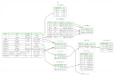
Documenting the file format
Since the first post on decoding the city database I have learned so much more about the structure of the D-Sat file format: where the image tiles are located, how they are indexed and which information the image header reveals, as well as that the file also contains points describing borders and highways.
-

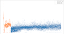
Visualising Entropy
Our quest to find the tile index of D-Sat 1 continues. I have described before, what I mean with “tile index” and I have also given a clue that I found something in the first part of the big blob of data
dsatnord.mpwhich I namedun1.dat. -
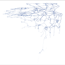
Finding something unexpected
After having visualised the “uncharted” parts of
dsatnord.mpour quest to find the index for the tiles continues. -
Searching for the index
Now let us inspect the unknown segments between tiles where I suspect the index for the tiles. First, we extract all unknown parts:
-
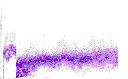
Getting an overview on the file content
In the last post we already gained a good overview on the distribution of tiles in
dsatnord.mp. Together with the first post this allows us to find the parts of the file which we do not understand, yet. -
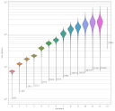
Visualising the tile size distribution
With mp.py’s
offsetscommand we can dump tile byte position, size, width and height as follows: -
Understanding the image header
One important question remains: Are the tiles in
dsatnord.mpstored with or without gaps? To find this out, we would need to know the actual byte size of each tile. But how to find that out? Well, one guess is that the data/file size of each image is stored in its header. The following Python code prints each consecutive 16 bits (two bytes) among the first 20 bytes as unsigned little endian integer: -
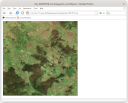
Viewing tiles with Firefox
Knowing the offsets of (potential) tiles, we can pick one (56057877) and extract the tile into a file:
-
Learning about the image format
The tiles are apparently stored in the lightning strike wavelet-compressed raster image format. Apparently, there exists no free software to work with such files. Here’s what we found:
-
Finding the tiles
To find the image tiles in
dsatnord.mpand possibly decode them, we had a look at the decompiledlsd26dll.dll. My colleague Jan found the functionCLsDecode::GetImageDataSizeand figured out that the first lines -
Decoding the city database
This post is a copy of the original web page I set up in 2005.
subscribe via RSS
This work is licensed under CC BY 4.0![]()
![]()