posts tagged with dsat
-
Solving a mystery (and finding something unexpected again)
We have now mapped almost all parts of
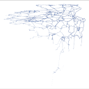
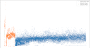
dsatnord.mpexcept for the one I have dubbed unknown2. Looking at the greyscale byte representation again, we can see roughly five regions with distinct patterns: -

Finding something unexpected again
This week I was poking around in the few remaining unknown territories of
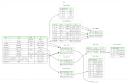
dsatnord.mpwith the excellent Kaitai Struct Visualizer (ksv) again. I have known for quite some time now that the city database is followed by some strings that seem to be related to the development of that database, namelyD:\Dsat\Dsat23\CityDlg.cppandc:\temp\cityname.bin. When I showed my colleagues that part using ksv, it looked like this: -
Documenting the file format
Since the first post on decoding the city database I have learned so much more about the structure of the D-Sat file format: where the image tiles are located, how they are indexed and which information the image header reveals, as well as that the file also contains points describing borders and highways.
-

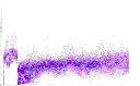
Visualising Entropy
Our quest to find the tile index of D-Sat 1 continues. I have described before, what I mean with “tile index” and I have also given a clue that I found something in the first part of the big blob of data
dsatnord.mpwhich I namedun1.dat. -
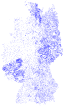
Finding something unexpected
After having visualised the “uncharted” parts of
dsatnord.mpour quest to find the index for the tiles continues. -
Searching for the index
Now let us inspect the unknown segments between tiles where I suspect the index for the tiles. First, we extract all unknown parts:
-
Getting an overview on the file content
In the last post we already gained a good overview on the distribution of tiles in
dsatnord.mp. Together with the first post this allows us to find the parts of the file which we do not understand, yet. -
Visualising the tile size distribution
With mp.py’s
offsetscommand we can dump tile byte position, size, width and height as follows: -
Finding the tiles
To find the image tiles in
dsatnord.mpand possibly decode them, we had a look at the decompiledlsd26dll.dll. My colleague Jan found the functionCLsDecode::GetImageDataSizeand figured out that the first lines -
Decoding the city database
This post is a copy of the original web page I set up in 2005.