Decoding the city database
This post is a copy of the original web page I set up in 2005.
D-Sat 1
For current development status see below.
Introduction
D-Sat 1 is a satellite atlas of Germany, consisting of pictures taken by russian COSMOS satellites in 1991. Besides viewing the pictures, it is also possible to search for over 13000 German cities (see screenshot) and to read the coordinates of the locations under the mouse pointer. D-Sat 1 was published in 1996, several versions followed (up to D-Sat 6 AFAIK), the companies which programmed and distributed D-Sat (SCOUT Systems and TopWare) are bankrupt now.
Besides the proprietary file format and compression algorithm of the pictures, the coordinate system (projection/datum) are AFAIK also unknown. My intention is to decode at least the data of the city database and to use that data to find out the used coordinate system.
The file dsatnord.mp contains the whole city database (dsatsued.mp also, but not tested). The first location is "Aach", offset unknown (extracted it once and then forgot it ...). I decoded the main parts of the city database (wasn’t so difficult, see below), but I recognized that the coordinates in the database differ from the coordinates which are shown if I put the mouse pointer on the basis of the "town sign".
So the basic problem is to find the connection between screen coordinates (under the mouse pointer), city coordinates (from the database) and true coordinates. Unfortunately, it is very boring work to write down the screen coordinates, because it is impossible for me to get them automatically. So the database of screen coordinates is very small. On the other hand, I have over 13000 coordinates of German cities with the problem that some of them are completely wrong (there existed a corrected update to D-Sat 1, I'm trying to decode that) and there is rule which part of the city has been chosen as reference point. Therefore, automatic comparison, for example, with OpenGeoDB data is very difficult.
Unfortunately, some rumours in the Internet also say that the pictures of D-Sat 1 are very badly geo-referenced. So maybe it is impossible to discover projection and datum, because it is just very badly geo-referenced GKK/Potsdam?
format of city data base
The format of the data is 64 bytes per city:
- 40 Bytes cityname (ASCII)
- 24 Bytes coordinates + other data (to identify), consisting of
-
Bytes 1-4: have exclusively the following values:
0 0 0 0 0 0 0 128 20 174 71 225 20 174 71 97 41 92 143 194 41 92 143 66 61 10 215 163 82 184 30 133 195 245 40 92 215 163 112 61 236 81 184 158 236 81 184 30 -
Bytes 5-7: easting, stored as little endian
-
Byte 8: always 65
-
Bytes 9-11: always 0
-
Byte 12: 1995 x 0; 584 x 32; 1878 x 64; 622 x 96; 1825 x 128; 593 x 160; 1889 x 192; 618 x 224
-
Bytes 13-15: northing, stored as little endian
-
Bye 16: always 65
-
Byte 17: 8486 x 9; 37 x 11; 3 x 17; 447 x 26
-
Bytes 18-24: always 0
-
Note: Bytes 1-4, 12 and 17 are geographically independent, that is, the values have nothing to do with the location of the cities.
some sample data
 Byte                     1    2    3    4    5    6    7    8    9   10   11   12   13   14   15   16   17   18   19   20   21   22   23   24
 Alsenz              __  41   92  143  194  184   76   25   65    0    0    0  192  140   11   85   65    9    0    0    0    0    0    0    0
 Alsfeld             __  20  174   71  225  165  173   31   65    0    0    0  224   81  122   85   65   26    0    0    0    0    0    0    0
 Alsheim             __  41   92  143  194   10  159   27   65    0    0    0  192  170   15   85   65    9    0    0    0    0    0    0    0
 Alsleben/ Saale     __   0    0    0  128   40  234   36   65    0    0    0    0  183  228   85   65   26    0    0    0    0    0    0    0
 Alt Bennebek        __   0    0    0  128    2   30   32   65    0    0    0  128   57    2   87   65    9    0    0    0    0    0    0    0
 Alt Bork            __ 236   81  184  158  134   88   39   65    0    0    0   64  148   28   86   65    9    0    0    0    0    0    0    0
 Alt Duvenstedt      __   0    0    0  128   72  138   32   65    0    0    0   96   47    0   87   65    9    0    0    0    0    0    0    0
 Alt Golm            __  41   92  143   66  103  241   41   65    0    0    0   32  105   46   86   65    9    0    0    0    0    0    0    0
 Alt Krenzlin        __ 236   81  184   30   67  245   35   65    0    0    0   64  118  146   86   65    9    0    0    0    0    0    0    0
 Alt Madlitz         __  41   92  143  194  244   64   42   65    0    0    0   64  137   55   86   65    9    0    0    0    0    0    0    0
 Alt Mahlisch        __  41   92  143  194   33  130   42   65    0    0    0  192   12   65   86   65    9    0    0    0    0    0    0    0
 Alt Meteln          __  41   92  143  194  123  252   35   65    0    0    0   96   18  193   86   65    9    0    0    0    0    0    0    0
 Alt Mölln           __ 236   81  184   30  106  154   34   65    0    0    0   64  141  177   86   65    9    0    0    0    0    0    0    0
 Alt Rehse           __  41   92  143  194   34  181   39   65    0    0    0   64   40  171   86   65    9    0    0    0    0    0    0    0
 Alt Schwerin        __  41   92  143   66  217   15   38   65    0    0    0  128  252  169   86   65    9    0    0    0    0    0    0    0
 Alt Schönau         __  41   92  143  194  133  207   38   65    0    0    0   64   22  179   86   65    9    0    0    0    0    0    0    0
 Alt Sührkow         __  41   92  143  194  180  156   38   65    0    0    0  160  111  202   86   65    9    0    0    0    0    0    0    0
 Alt Tucheband       __   0    0    0  128  189  174   42   65    0    0    0  192  165   73   86   65    9    0    0    0    0    0    0    0
 Alt Zauche          __   0    0    0    0  203  206   41   65    0    0    0  128  246    3   86   65    9    0    0    0    0    0    0    0
 Alt Zeschdorf       __   0    0    0    0  228  146   42   65    0    0    0  128   30   61   86   65    9    0    0    0    0    0    0    0
 Alt-Schadow         __  20  174   71   97  112  159   41   65    0    0    0  192  164   25   86   65    9    0    0    0    0    0    0    0
 Altbach             __  20  174   71   97  167   30   32   65    0    0    0   32  249  158   84   65    9    0    0    0    0    0    0    0
 Altbrandsleben      __   0    0    0  128  188  249   35   65    0    0    0    0  170   11   86   65    9    0    0    0    0    0    0    0
put into an image ...
OK, so let us take all 13378 cities, their easting/northing and put them into a cartesian coordinate system: orte.ps.gz. THe function I used to transform the coordinates into PostScript-compatible values is: PS_E = (500.0/1835000.0) * (E-1114000), PS_N = (1000.0/262144.0) * (N-5505000)\
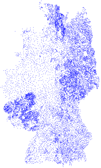
Nice, isn't it? :-)\ (besides an east-west-compression – which may result from conversion to Postscript coordinates?!)
For me this picture was the proof that I really found the coordinates of the cities and not some other data. I also tried to colorize the points, depending on the value of the unidentified bytes, but that yielded no pattern – the colors were spread all over Germany.
comparison to known data
explanation of the columns in the following table:
- file_E/file_N: easting/northing which I got from the decoded city database
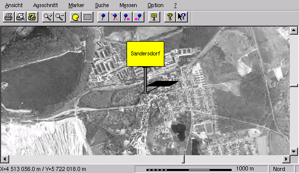
- screen_E/screen_N: easting/northing which is shown on screen, when I put the mouse pointer on the basis of the town sign (see screenshot)
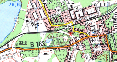
- GKK/Potsdam, UTM/WGS84: I tried to find the locations of the town signs in the topographical map 1:25000 and wrote down the coordinates (see red cross in screenshot TK25 and compare with screenshot D-Sat 1). Of course, this is very error prone, because it's impossible to get the exact location.
- screen_E-GKK_E: difference between screen-easting and GKK/Potsdam-easting
- screen_N-GKK_N: difference between screen-northing and GKK/Potsdam-northing
The fact, that I have only two geo-referenced Top25-maps is the reason for the few data here. :-(
| city | file_E | file_N | screen_E | screen_N | GKK/Potsdam_(4) | UTM/WGS84_(33U) | screen_E - GKK_E | screen_N - GKK_N |
|---|---|---|---|---|---|---|---|---|
| Salzfurtkapelle | 2488688 | 5629157 | 4507038.0m | 5729278.0m | 4512121E - 5728869N | 304711E - 5730783N | -5083 | 409 |
| Wolfen | 2501091 | 5628611 | 4513170.0m | 5726920.0m | 4518355E - 5726409N | 310938E - 5727642N | -5185 | 511 |
| Sandersdorf (Screenshots: TK25, D-Sat1) | 2501138 | 5627385 | 4513056.0m | 5722012.0m | 4518214E - 5721479N | 310460E - 5723154N | -5158 | 533 |
| Thalheim | 2496565 | 5628002 | 4510842.0m | 5724544.0m | 4515992E - 5724054N | 308346E - 5725823N | -5150 | 490 |
| Jeßnitz | 2507842 | 5629039 | 4516584.0m | 5728546.0m | 4521814E - 5727937N | 314323E - 5729459N | -5230 | 609 |
| Greppin | 2506254 | 5627847 | 4515666.0m | 5723788.0m | 4520853E - 5723274N | 313171E - 5724839N | -5187 | 514 |
| Paplitz | 2662879 | 5640168 | 4595124.0m | 5771098.0m | 4601091E - 5769517N | 395230E - 5767732N | -5967 | 1581 |
| Horstwalde | 2653560 | 5641043 | 4590582.0m | 5774734.0m | 4596532E - 5773231N | 390830E - 5771630N | -5950 | 1503 |
In dsat_difference_vector.ps I have drawn the difference vectors to the real locations (screen_E-GKK_E and screen_N-GKK_N). Note: the signs are drawn wrong (always positive). To me that looks good, that is, there seems to be a systematic error to the real locations. generation of file (plus header/footer):
awk '{f=200} {print "newpath " ($4-4507000)/f " "($5-5720000)/f \
      " 1 0 360 arc fill \
      newpath " ($4-4507000)/f " " ($5-5720000)/f " moveto " \
      ($6-4507000)/f " " ((2*$5)-$7-5720000)/f " lineto stroke "}' \
      < vergleich_2  > dsat_difference_vector.ps
Difference vectors: 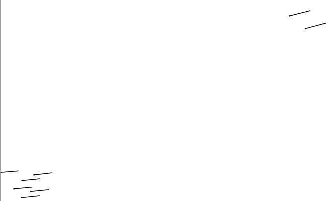
it gets worse
In D-Sat you can put markers on the map to remember locations. The
location of the markers is saved in dsat.ini in a very simple
format:
M005Key1=5
M005Key2=32838
M005Key3=248766
M005File=
Key1 selects the symbol which is shown on the screen, so the other two values should be the coordinates of the marker. The problem is very simple:
 city           : file_E  : file_N  :  screen_E  : screen_N  :dsat.ini :dsat.ini
 List           : 1853914 : 5719936 :  4261239.0 : 6101200.0 :   32838 : 248766
 Oberstdorf     : 2242906 : 5509437 :  4371513.0 : 5252560.0 :  881472 : 359034
 Selfkant       : 1128882 : 5610221 :  4068213.0 : 5665063.0 :  468978 :  55734
 Deschka        : 2890943 : 5620266 :  4704306.0 : 5688157.0 :  445878 : 691830
(BTW: these are the most northern, southern, western and eastern
cities inside D-Sat.) The first two values file_E/file_N are extracted
by me from dsatnord.mp, the second two values screen_E/screen_N are
shown on the screen and the third two values are from the markers, I
put on the city location.
Help!
If you have ideas that could help to decode any of that coordinates, I would be glad to hear from you. I'm also interested in information regarding the rumour that the pictures in D-Sat 1 are very badly geo-referenced and so it is impossible to get correct coordinates.
Current development status
Thanks to Mikael Rekola, because he pointed out that the coordinates in the city database could also be stored as (long) floating point. And that could be indeed true! I'm still doing some comparisons, but actually the floating point values again give a map of Germany: new.ps.gz. This map is much more distorted, if I don't scale it appropriately.
The second and third column show the new values for locations given above:
ort file_e   file_n    screene screenn gkk_e   gkk_n
sfk 720056.4 5739412.0 4507038 5729278 4512121 5728869
wol 726257.7 5737228.0 4513170 5726920 4518355 5726409
sdf 726281.1 5732326.0 4513056 5722012 4518214 5721479
tha 723994.5 5734795.5 4510842 5724544 4515992 5724054
jes 729633.4 5738941.0 4516584 5728546 4521814 5727937
gre 728839.4 5734175.0 4515666 5723788 4520853 5723274
pap 807151.8 5783457.0 4595124 5771098 4601091 5769517
hor 802492.2 5786956.0 4590582 5774734 4596532 5773231
Last change: 2005-03-26